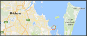
Coochiemudlo island
Co-ordinates: -27.570081, 153.331703
Access: By ferry – From Victoria Point. By boat – Beach where safe.
Known locally as Coochie, this cute little island is just 1 km from the mainland at Victoria Point and totals just 5 sq km in area. The name originates from the Aboriginal terms kutchi, which means red & mudlo which means stone. This in turn refers to the red cliffs on the South West of the island which also serve as a feature of the island, visible from the mainland.
Matthew Flinders set foot upon Coochie in the late 1700s as he was trying to find a large enough passage to give access to the interior. Unfortunately he failed but his landing is reenacted every year on the Sunday closest to the 19th of July and has a stone monument to mark his landing on the Eastern side of the island.
Around 20 years later, Thomas Pamphlett & John Finnegan were shipwrecked on Moreton island but were shown around the shores of the Moreton Bay islands by friendly Aborigines. In 1823, General John Oxley rescued them as he was imitating Flinders’ quest to find a route in land and due to the Aborigines showing Pamphlett & Finnegan around, they were able to show Oxley the mouth of what we now call the Brisbane River.
In the late 1950s, Alfred Grant began developing Coochiemudlo island into a residential plots, taking away its previous timber farming history. Despite the small island feel, the population of less than 1,000 people still manage to enjoy a cricket pitch, a 9 hole golf course, tennis courts, a BMX track plus much more.
Thanks to Coochie island’s beaches on 3 sides, there is always a beach to find shelter from the wind despite the direction of the wind.
Next – Check out Peel Island below